Post-doctoral research fellow
The Center for Immersive Experiences at The Pennsylvania State University (immersive.psu.edu), in collaboration with other units at Penn State (such as ChoroPhronesis, chorophronesis.psu.edu, and Teaching and Learning with Technology), is hiring two Post-Doctoral Researchers focusing on areas such as immersive analytics, immersive learning, immersive decision-making, or serious games. The postdocs will be working in vibrant multidisciplinary teams that are addressing a range of topics that see transformative changes due to the paradigm shifting nature of immersive technologies.
Example topics may include empirically validating immersive technologies across the academic spectrum; designing Immersive technologies for environmental decision making; exploring scientific foundations of immersive technologies. The Postdocs will be coordinated through The Center for Immersive Experiences at Penn State (Director: Dr. Alexander Klippel) but will work across projects at The Pennsylvania State University. Ongoing projects include: The Science of Being There – Immersive Virtual Field Trips for Geospatial Sciences; Visualizing Forest Futures – VIFF; Visualization and Access to Informal Settlements through Immersive Experiences; Transforming Education through Immersive Technologies; Immersive Storytelling for General Education Across the Academic Spectrum; Digital Innovation through Immersive Technologies: Establishing New Paradigms for Environmental Decision Support. Postdocs can have a range of qualifications and can come from several different backgrounds such as computer science, engineering, GIScience, landscape architecture/architecture, education, or psychology.
Any subset of the list below is possible, but a strong focus is placed on technical skills as well as skill related to the quantitative and qualitative evaluation of immersive technologies. The ideal candidate must be adaptable, capable of thriving in a rapidly changing environment, where new approaches and technologies may change quickly. Qualifications include: 3D modeling and visualization skills (modeling for real time rendering a plus); programming skills (in particular C#); experience in the development of software for commercial or open source applications; code management system such as git; application development with game engines such as Unity3D and Unreal Engine; experience in learning assessment; experience in the design of experimental evaluations of (immersive) learning; communication skills for interacting with academics, instructional designers and others across the academic spectrum.
The initial appointment is intended for 12 months but excellent options for an annual renewal exist depending on performance. The start date is envisioned for the winter 19/20 and can be as early as December 1, 2019. Salary is commensurate with experience and qualifications. The positions are full-time, benefits-eligible academic professional on a 12-month service basis. Eligibility for benefits are contingent on your citizenship or work authorization.
The following documents are required for the application: Cover letter (no more than 2 pages), CV/Resume, link to a portfolio of projects/experiences (if applicable), up to three scientific publications, three academic references (letter writers). For questions about the positions please contact Dr. Klippel at klippel@psu.edu. Application materials should be uploaded through psu.jobs (psu.jobs/job/88810)
Fully funded PhD/Master positions focusing on immersive experiences and technologies
The Center for Immersive Experiences (https://immersive.psu.edu/) in collaboration with associated departments such as Geography (GIScience) at The Pennsylvania State University, invites aspiring young scientists to apply for several open PhD and Master positions in the area of immersive experiences and technologies. CIE is currently developing over 30 projects related to xR (augmented, mixed, and virtual reality) and we seek creative and technically skilled minds that are keen to complement our team.
In this dynamically evolving field of immersive technologies we are particularly interested in intrinsically motivated researchers who embrace and love technology, seek to understand how design choices affect experiences and performance, and appreciate working in a team to get inspired and be an inspiration for others. The PhD/masters positions will allow making contributions to a variety of projects and areas that see transformation through immersive experiences or focus on fundamental questions of how and why immersive experiences allow unprecedented insights and experiences, not possible before.
Technical skills to design immersive experiences or a solid basis that would allow for learning the necessary skills quickly are essential for the offered positions. Bachelor or masters training in information or computer science, geomatics, GIScience, education technology or other related fields is expected.
Applicants should have a good command of English both spoken and written. Applications from females and under-represented groups are particularly encouraged.
Students who successfully apply will be offered a 4-year funded position (stipend, tuition and benefits) for PhD students and a 2-year position for masters students with the option to convert it into a PhD, subject to yearly performance reviews.
If you are interested, please contact Dr. Alexander Klippel (klippel@psu.edu).
xR Developer
The Center for Immersive Experiences (CIE) at Penn State is seeking an experienced xR Developer to complement our growing and successful team (immersive.psu.edu/organization). Penn State's Center for Immersive Experiences is a university-wide supported unit that has the goal to deliver immersive experiences for research, education, and outreach to the Penn State community.
Penn State will be equipped to meet the needs of students, faculty, and a society at large that is progressively more reliant on immersive technology with the opening of the Center for Immersive Experiences (CIE) on the University Park campus.
The center, with physical space in Pattee Library and collaborators in 11 different academic units at the University, will feature comprehensive services around teaching, learning and research involving immersive technology by increasing access to virtual reality, augmented reality, 360-degree video, mixed reality and more.
The center — on schedule to open in mid-November — will serve as a conduit for immersive experiences at the University by championing interdepartmental projects; incorporating immersive tech into classrooms; and giving Penn Staters access to a “sandbox” of immersive technologies. The center’s physical space will feature virtual reality bays and a lab that can function as a theater, breakout room or conference space.
Administrators believe Penn State’s collaborative culture, institutional strengths and research focus make it an ideal place to unlock immersive technology’s educational potential.
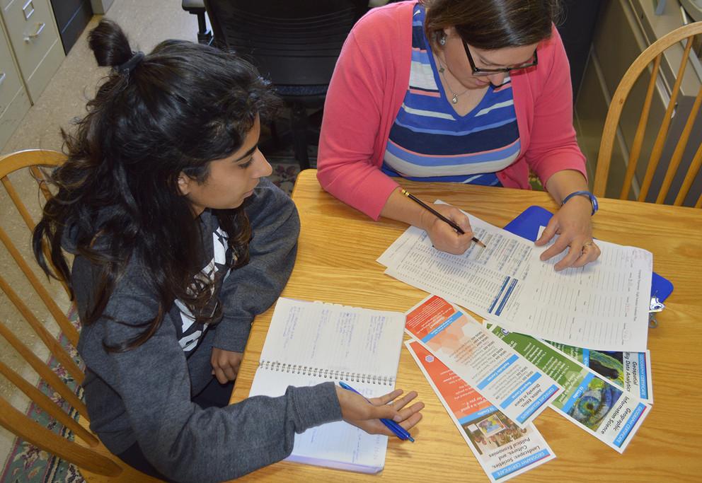
For a project in a geographic information systems (GIS) class in Penn State's Department of Geography, Alexis Fisher sought to spotlight the wage gap in the United States. She had familiarity with the topic, but when she began plotting a story map using Esri’s ArcGIS online tools, the data really came to life.
Fisher, a senior majoring in cyber security analytics and operations with a focus in geopolitics, entered historical wage data broken down by counties with variables for gender and ethnicity, to create an interactive map with text, videos, and graphics.
“The tools really helped illustrate the statistics,” Fisher said. “Without the awesome maps I was able to create using Esri software, people wouldn’t have been able to visualize the statistics as effectively.”
Penn State University Libraries will observe GIS Day—an annual event celebrating the technology of geographic information systems (GIS)—on Tuesday, Nov. 12, with activities designed to bring together both new and experienced users of geospatial information across disciplines.
This year’s program, “Exploring the World Through Geovisualization,” aims to foster awareness of geospatial visualization, online mapping, and geospatial data science and the ways these applications are being used on campus, in the community, and beyond. GIS use across the University is enabled through access to Esri GIS software, including ArcGIS Pro and ArcMap, along with ArcGIS Online.
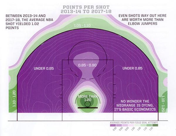
As a geography student, Kirk Goldsberry never needed an excuse to make maps. The trick was finding ways to combine cartography with his other love — basketball.
The Penn State geography alumnus found professional success combining his passions. He is a leader in basketball analytics, having worked as an NBA front office executive and as a writer for ESPN.
In his most recent work, The New York Times best-selling book “SprawlBall: A Visual Tour of the New Era of the NBA,” Goldsberry examines how the proliferation of the 3-point shot, and other trends, have helped transform the league, perhaps in unexpected ways.
“My book is just another example of a geographer noticing a change, searching for its essential causes, and trying to explain them via the mighty combination of maps, stats and prose,” Goldsberry said.
Penn State students who want to customize their bachelor’s degree in geography, add a specific topic in geography to their major, or enhance their career as a non-degree student can now complete undergraduate certificates in geography.
“Certificates are credentials that recognize mastery of a specific area in the discipline,” said Jodi Vender, undergraduate adviser in the Department of Geography. “Ours are 12 credits — fewer credits than a minor — so they fit more easily into a degree program. They can be used as milestones for accomplishment in a specific domain or can stand alone.”
The College of Earth and Mineral Sciences through the Earth and Environmental Systems Institute (EESI) at The Pennsylvania State University, University Park, PA, seeks to hire tenure-line faculty at the assistant or associate rank who study Earth and environmental sciences using new data-driven tools and methods. Candidates for the rank of associate professor typically will have several years of research experience and already hold tenure at another institution and/or qualify for immediate tenure at Penn State. Successful candidates will have expertise in at least one of the following areas: data mining, machine learning, artificial intelligence, or deep learning. We seek dynamic scientists who want to teach and lead in the emerging field of data analytics on integrated topics of Earth and environmental science as they relate to land-water systems. Relevant research expertise should include at least one of the following: remote sensing, numerical modeling, groundwater chemistry, nature-society interactions, decision analysis, high performance computing, or machine learning and artificial intelligence. The position will involve a joint appointment between EESI and one Department among Geography, Energy and Mineral Engineering, and Geosciences. The tenure home will be determined based on the research skills and interests of the candidate, after the on-site interviews have been conducted.
The selected applicants will be responsible for research and teaching in their respective Departments, along with service for Departments and EESI. We envision that the new faculty will coordinate in offering new courses in environmental data analytics, aimed especially for graduate and undergraduate students in environmental studies, science and policy across the College of Earth and Mineral Sciences. Candidates should have earned a Ph.D. in either Earth Science, Geosciences, Geography, Energy Science, Meteorology, Computer Science, Engineering or a clearly related field in the engineering, natural or social sciences by the time of hire.
Candidates must demonstrate expertise and research productivity in data-driven science and show strong interest in interdisciplinary research and teaching. Excellence in teaching, research, and service is expected of professors employed by Penn State, as is the development of an externally funded research program. The Pennsylvania State University is committed to and accountable for advancing diversity, equity, and inclusion in all of its forms. We foster a culture of inclusion that supports numerous diversity initiatives and leverages the educational and institutional benefits of diversity. We value inclusion as a core strength and an essential element of our public service mission.
To apply, please upload: cover letter; curriculum vitae, including publications list; a description of future research plans; teaching interests; and a statement of commitment towards diversity and inclusion. The review of applications will begin October 1, 2019 and continue until all positions are filled. Inquiries can be sent to Professor Guido Cervone (cervone@psu.edu), Chair of the hiring committee.
The Department of Geography at The Pennsylvania State University in State College, Pennsylvania invites applications for a tenure-track Assistant Professor faculty position in Health Geography with a focus on Substance Use and Misuse. Preference will be given to candidates with a research focus in the United States and who utilize quantitative and spatial techniques to address subjects including but not limited to social determinants, population patterns, and health care delivery pertaining to substance use and misuse. Excellence in teaching, research, and service is expected of professors employed by Penn State Geography, as is the development of an extramurally funded research program. A Ph.D. in Geography or a related field is expected, and applicants will have completed all requirements of the Ph.D. degree before August 1, 2020.
This position is part of a strategic hire of up to 12 new faculty members from multiple disciplines, who will be part of Penn State’s newly launched Consortium to Combat Substance Abuse (CCSA) https://combatsubstanceabuse.ssri.psu.edu. The position is co-funded by the Social Science Research Institute www.ssri.psu.edu. The CCSA aims to promote collaborative, interdisciplinary and translational research toward leadership, innovation and impact in addressing substance use and misuse. The successful applicant will have the opportunity to engage with a range of Centers and Institutes across the University.
Applicants should upload the following materials:
- a letter describing how they would contribute to the Department’s research and teaching program;
- a complete curriculum vitae;
- a maximum of five reprints;
- and the names and addresses (including e-mail) of three references.
Applicants should provide evidence, either woven through their application materials, or as a separate diversity statement, of a commitment to fostering diversity, equity, inclusive excellence and belonging, and of engagement that creates an inclusive environment in their department/workplace.
Review of applications will begin October 25, 2019, but applications will be accepted until the position is filled.
Penn State is committed to and accountable for advancing diversity, equity, and inclusion in all of its forms. We embrace individual uniqueness, foster a culture of inclusion that supports both broad and specific diversity initiatives, and leverage the educational and institutional benefits of diversity. We value inclusion as a core strength and an essential element of our public service mission.
Questions about the position should be directed to the search committee chair, Dr. Brian King, Department of Geography, The Pennsylvania State University, 302 Walker Building, University Park, PA 16802; Phone: (814) 865-26126; Fax: (814) 863-7943; E-mail: king@psu.edu.
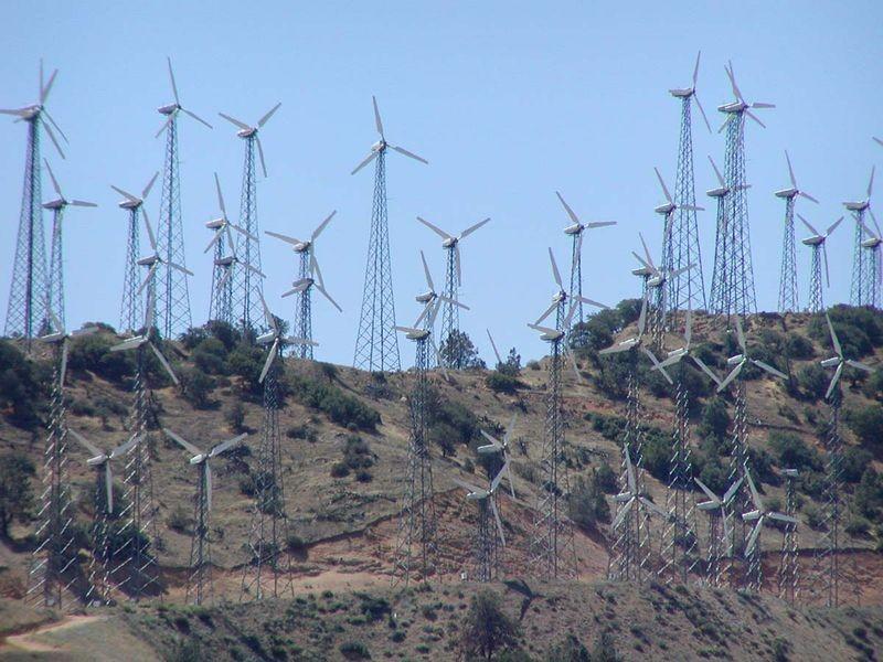
The wind is always blowing somewhere, but deciding where to locate a wind farm is a bit more complicated than holding up a wet finger. Now a team of Penn State researchers have a model that can locate the best place for the wind farm and even help with 24-hour predictions of energy output.
"Normally, people planning to build a wind farm will look for good terrain and an average wind speed that is not too strong and not too weak, but consistent," said Guido Cervone, professor of geography, and meteorology and atmospheric science. "We found a more accurate and efficient way to look at wind predictability at specific locations, a key factor when considering building a new wind farm. With fossil fuels and nuclear energy you know exactly how much energy you will have. But wind is not like that."
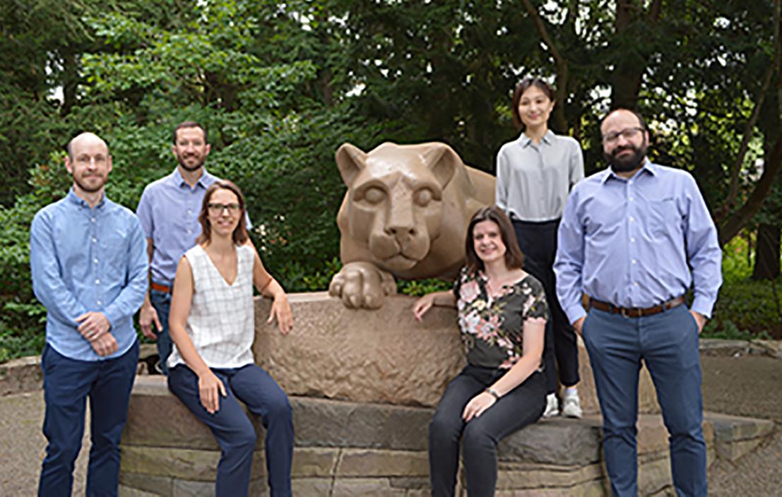
Six new tenure-line geography faculty started this fall in the Department of Geography, College of Earth and Mineral Sciences. They will conduct research on a wide variety of subjects including water, climate change, natural hazards, remote sensing, social networks, data mining, economics, and inequality and diversity.
“The new geographers are bringing in not only their scientific expertise but also experience in using multiple research methods, and a dedication to engaging livelihoods and environments,” said Cynthia Brewer, professor and head of the department. “Their expertise will also be used to create new courses for our students.”


